While the saints of Northumberland wandered the coastlines, the Cistercians of Cumbria conquered the wilderness.
To walk the Cistercian Way is to trace the footprint of the “White Monks”—an order that arrived in 1127 and transformed a swampy, “worthless” valley into one of the most powerful ecclesiastical machines in Europe.
This 25-mile route (often broken into two or three days) takes you from the edge of the treacherous Morecambe Bay into the heart of the Furness Peninsula.
It is a pilgrimage of red sandstone, ancient “corpse roads,” and the enduring silence of the Cumbrian fells.
1. The Gateway: Grange-over-Sands to Cartmel (The Priory Lands)
The journey begins at Grange-over-Sands. Historically, this was the point where pilgrims crossing the hazardous sands of Morecambe Bay would finally reach safety.
The History:
Your first major destination is Cartmel Priory. Founded in 1189 by William Marshal, 1st Earl of Pembroke, it survived the Dissolution of the Monasteries in 1536 because the villagers fought to keep it as their parish church.
Practical Trail Detail:
- The Climb: From Grange, the path ascends Hampsfell. At the summit stands Hampsfell Hospice, a sturdy limestone tower built by the local vicar in 1846 to provide shelter for travelers.
- The View: On a clear day, you can see the entire Cumbrian mountain range to the north and the Pennines to the east. It provides the “theological perspective” of the pilgrim: the vastness of creation versus the smallness of the traveler.
- Village Stop: In Cartmel, do not just look at the Priory from the outside. Enter and find the Cromwellian Doors, still scarred by the hoofprints of Parliamentarian horses from the Civil War.
2. The High Ground: Cartmel to Ulverston
Leaving the lush valley of Cartmel, the route turns rugged. You are now entering the lands where the monks grazed their vast flocks of sheep—the source of their immense wealth.
The History:
You will pass through Haverthwaite and over the Bigland Heights. This area was vital for the “bloomeries” (early iron smelting sites) managed by the monks.
The Cistercians were the tech-titans of the medieval world, harnessing water power and mineral wealth.
Practical Trail Detail:
- Terrain: This section involves significant elevation changes. The path can be boggy even in summer. Ensure your footwear is treated for peat and mud.
- The “Corpse Road”: You will walk sections of ancient tracks used to carry the dead from remote farmsteads to consecrated ground. There is a palpable sense of “layers of time” here.
- Village Stop: Ulverston is a vibrant market town. Visit St. Mary’s Church; although largely rebuilt, its foundations date back to the 1100s and it served as a spiritual outpost for the Abbey.
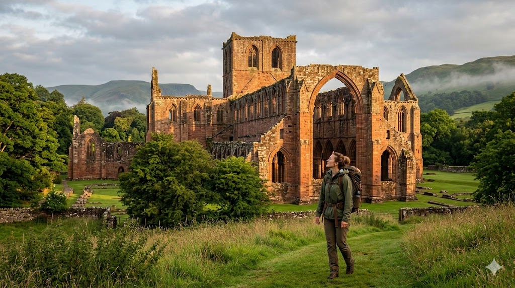
3. The Grand Finale: The Vale of Nightshade (Bekansgill)
The final stretch takes you from the heights of Birkrigg Common down into the hidden valley where Furness Abbey sits.
The History:
The Abbey was built in Bekansgill (The Valley of Deadly Nightshade). The monks chose this secluded spot specifically for its isolation.
By the 15th century, the Abbot of Furness was so powerful he had his own private army and a seat in the House of Lords.
The Tangible Experience:
- The Red Sandstone: Unlike the grey limestone of the north, the Abbey is built from local New Red Sandstone. In the evening light, the ruins appear to glow with a deep, blood-red hue.
- The Sedilia: Inside the ruins, look for the four-seat sedilia (stone seats for the clergy). They are among the finest examples of medieval stone carving in England, featuring delicate canopies that survived the destruction of the roof.
- The Abbey Museum: It houses the Furness Crozier, a rare 12th-century gilded staff found in a grave, offering a rare look at the physical regalia of an Abbot’s power.
The Pilgrim’s Practical Toolkit
- Distance: Approx. 25 miles (40km).
- Difficulty: Moderate. Some steep climbs on Hampsfell and Bigland, but the coastal stretches are flat.
- Waymarking: Look for the Cistercian Way markers (often featuring a monastic cowl or a simple cross). However, a dedicated OS Map (Explorer OL7) is essential as some sections through farmstead gates can be confusing.
- Transport: The route is uniquely accessible by rail. You can start at Grange-over-Sands station and finish near Roose or Dalton station, making it a “green” pilgrimage.
- The “Silent” Window: Visit Furness Abbey at the very opening (10:00 AM) or an hour before closing. When the school groups and tourists leave, the “genius loci” (spirit of the place) returns.
Conclusion: The Prayer of the Hands
The Cistercian Way reminds us that the monastic life was not merely one of quiet contemplation in a cell.
It was an active, muscular faith.
As you stand among the soaring arches of Furness, you realize that these men didn’t just pray for the world; they built a world.
For the modern traveller, this route offers a chance to reconnect with the idea that our work and our wanderings can, in themselves, be a form of worship.
Leave a Reply