Northumberland and the Scottish Borders are home to two of Britain’s most evocative long-distance trails.
While both routes converge on the “cradle of Christianity”—Holy Island—they offer vastly different experiences. One is a meditative journey through the rolling hills of the Borders; the other is a coastal epic passing through the seats of ancient kings.
If you are planning your next pilgrimage but can only choose one, this guide breaks down the terrain, history, and logistics to help you make the right call.
The Core Comparison
| Feature | St Cuthbert’s Way | St Oswald’s Way |
| Theme | The Path of the Monk | The Epic of the King |
| Distance | 62 miles (100 km) | 97 miles (156 km) |
| Typical Duration | 4–6 Days | 6–10 Days |
| Route Direction | West to East (Melrose to Island) | North to South (Island to Wall) |
| Highest Point | Wideopen Hill (368m) | Simonside Hills (approx. 300m) |
| Key Highlights | Melrose Abbey, Cheviots, The Sands | Bamburgh Castle, Dunstanburgh, Hadrian’s Wall |
| Best For | Spiritual reflection & hill walking | History lovers & coastal scenery |
St Cuthbert’s Way: The Meditative Journey
Named after the 7th-century monk and bishop, this trail follows the trajectory of Cuthbert’s life. It begins at Melrose Abbey, where he entered monastic life, and ends at his final resting place on Holy Island.
Terrain & Highlights
The route is famed for its “changing face.” You begin with the sharp, triple-peaked Eildon Hills, offering views across the Scottish Borders.
You’ll then track the River Tweed before the most challenging section: the crossing of the Cheviot Hills.
The pinnacle is Wideopen Hill, the literal and metaphorical halfway point, providing 360-degree vistas into both Scotland and England.
The Climax: The Pilgrim’s Path
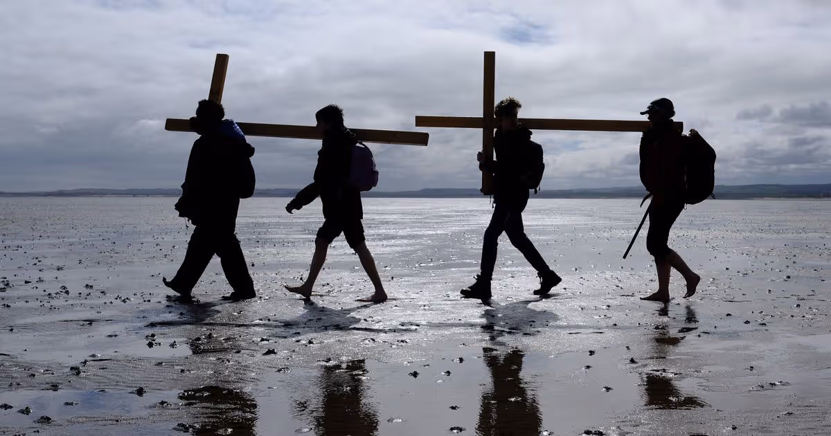
The defining moment of this route is the crossing to Lindisfarne.
While most visitors use the tarmac causeway, pilgrims follow the “Pilgrim’s Path”—a line of wooden poles marking a 3-mile trek across the tidal mudflats.
Warning: This must be timed precisely with tide tables; getting it wrong is dangerous.
St Oswald’s Way: The Royal Saga
If Cuthbert’s Way is about the spirit, Oswald’s Way is about power and the birth of a nation. It traces the footsteps of King Oswald, the 7th-century warrior who unified Northumbria.
Terrain & Highlights
This route is a tale of two halves. The northern section is dominated by the Northumberland Coast AONB.
You’ll walk through the shadows of Bamburgh Castle (Oswald’s capital) and the haunting ruins of Dunstanburgh.
The southern half turns inland, moving through the Coquet Valley and up into the rugged Simonside Hills.
The journey concludes at Heavenfield, the site of Oswald’s decisive victory, where the trail joins Hadrian’s Wall.
Logistics & “Thin” Sections
Unlike the more consistently supported St Cuthbert’s Way, St Oswald’s Way has a “remote” stretch between Rothbury and Heavenfield.
Accommodation is scarcer here, and walkers must plan their food and water carefully for these final 30 miles.
The Itineraries: Day-by-Day
St Cuthbert’s Way (The 5-Day “Classic” Pace)
- Day 1: Melrose to St Boswells (7 miles): A gentle start along the River Tweed, passing the foot of the Eildon Hills.
- Day 2: St Boswells to Jedburgh (11 miles): Following the Roman road of Dere Street and riverside paths.
- Day 3: Jedburgh to Morebattle/Kirk Yetholm (14 miles): The climb begins. You move from lush valleys into the foothills of the Cheviots.
- Day 4: Kirk Yetholm to Wooler (13 miles): The “Big One.” You cross the border into England at Wideopen Hill. This is the highest point of the path.
- Day 5: Wooler to Holy Island (17 miles): A long final push through Fenwick and over the sands to the Priory.
St Oswald’s Way (The 8-Day “Balanced” Pace)
- Day 1: Holy Island to Belford (12 miles): Departing the island (tide-dependent) and heading through the kyloe hills.
- Day 2: Belford to Bamburgh/Seahouses (11 miles): Reaching the coast and the formidable sight of Bamburgh Castle.
- Day 3: Seahouses to Craster (10 miles): Iconic coastal walking. Passing Dunstanburgh Castle ruins.
- Day 4: Craster to Warkworth (13 miles): Long beach stretches ending at the medieval castle and hermitage of Warkworth.
- Day 5: Warkworth to Rothbury (15 miles): Leaving the sea behind to follow the winding River Coquet inland.
- Day 6: Rothbury to Knowesgate (14 miles): A rugged ascent into the Simonside Hills with heather-clad moorland.
- Day 7: Knowesgate to Kirkwhelpington (8 miles): A shorter “recovery” day through Northumbrian farmland.
- Day 8: Kirkwhelpington to Heavenfield (14 miles): The final trek to the Roman Wall and the site of Oswald’s victory.
Which One Should You Choose?
Choose St Cuthbert’s Way if…
- You want a shorter commitment: It’s the perfect “first pilgrimage” and can be completed in a week-long holiday.
- You prefer hills over beaches: The Cheviot sections offer a true “wild” feel that the coastal path lacks.
- You are seeking “Communitas”: Because it is a more popular route, you are more likely to meet fellow pilgrims in the “Sanctuary” stays along the way.
Choose St Oswald’s Way if…
- You love castles and coastline: This is arguably the most scenic coastal walk in England.
- You want to “walk into the past”: The transition from the medieval coast to the Roman frontier of Hadrian’s Wall is a history lover’s dream.
- You want a physical challenge: The extra 35 miles and the more remote inland sections require a higher level of endurance.
Essential Planning Tips for 2026
- Tide Times: For both routes, the Holy Island tides are the “gatekeepers.” Check the official Northumberland County Council tide tables before booking your start or end dates.
- The Pilgrim Passport: Both routes have official “Passports.” Collecting stamps at local churches and pubs isn’t just a gimmick—it’s a great way to support the local economy and claim your completion certificate.
- Best Time to Walk: May to September offers the best weather. However, the “Haar” (sea mist) can roll in quickly on the coast, so even in summer, waterproofs and a compass are non-negotiable.
A Journey Beyond the Map
Whether you choose the monk’s path or the king’s epic, remember that a pilgrimage is fundamentally different from a hike.
A hike is about the destination; a pilgrimage is about the transformation that happens between the miles.
In Northumberland, the landscape is so steeped in history that you aren’t just walking on the ground—you are walking through time.
You will likely start your journey with a heavy pack and a busy mind, but by the time you reach the final “stamping station,” you’ll find the pack feels lighter and the silence feels more comfortable.
Whichever Way you choose, prepare for the weather, respect the tides, and keep your heart open to the “thin places” where the veil between the past and the present seems to disappear.
The Northumbrian landscape is waiting to tell you its story—all you have to do is start walking.
Leave a Reply